The Export Isolines command (File->Export->Export Isolines) saves coordinates of all currently displayed isolines (the Isolines Graph Type has to be selected) into a Project_Property_Isolines.txt text file (e.g., Furrow_Pressure_Head_Isolines.txt). Below is an example of this file for the Furrow project. In the text file, a definition of each isolines is given first (e.g., Isoline 1, Value=-60.000, Segment 1), followed by the x and z coordinates of sequential points, in which the isoline crosses edges of finite elements. The Export Isolines command can be used, for example, to export coordinates of the groundwater table. In such case, a custom scale with one single value (h=0) could be prepared and exported.
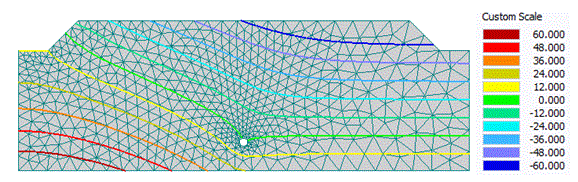
An example of the Project_Property_Isolines.txt text file.
; Program : HYDRUS 2.03
; File Version : 1
;-------------------------------------
; Isoline 1, Value=-60.000, Segment 1
;-------------------------------------
; Description:
; C1 = x-coordinate [m]
; C2 = z-coordinate [m]
;------C1------|------C2------|
2.761816e+000 8.381839e-001
2.670929e+000 8.391035e-001
2.577883e+000 8.403773e-001
2.559808e+000 8.406094e-001
2.542170e+000 8.409753e-001
….
1.537666e+000 9.790872e-001
1.477832e+000 1.000000e+000
Return to File Menu.